
Guidebook for East Crete
Φαγητό
The best reastaurant in Ierapetra!!
You can sit next to the sea.
The service is perfect, they are super friendly and quick.
They have fresh fish every day.
The food is delicious! They have a big range of wine and other drinks.
100% Recommended
16 personas locales recomiendan

Βίρα Πότζι
82 Str. SamouilThe best reastaurant in Ierapetra!!
You can sit next to the sea.
The service is perfect, they are super friendly and quick.
They have fresh fish every day.
The food is delicious! They have a big range of wine and other drinks.
100% Recommended
SICILIANA
Plateia EleftheriasPelagos Sea Side Restaurant
L' angolo
37 Akti MarkopoulouAlatsi tou Vasili
Kaliotzína
Eparchiaki Odos Koutsouras-StavrochoriouCafe and Brunch
G Spot
36 KiprouWaikiki Cafe-Beach Bar
2 Georgiou TzardiREPUBLIC 32
32 DimokratiasCasablanca
5 ΛακέρδαΑξιοθέατα
The Archaeological Collection of Ierapetra started its opetation in the late 19th century in Ierapetra, when its antiquities-loving residents founded the Educational Association of Ierapetra. The purpose of the club was to gather and preserve the region’s antiquities, as well as to create a museum collection.
19 personas locales recomiendan
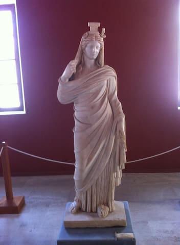
Archaeological Collection
ke DimokratiasThe Archaeological Collection of Ierapetra started its opetation in the late 19th century in Ierapetra, when its antiquities-loving residents founded the Educational Association of Ierapetra. The purpose of the club was to gather and preserve the region’s antiquities, as well as to create a museum collection.
The fort Kales in Ierapetra was built by the Venetians in the 13th century AD, to protect the town of Ierapetra from its enemies. In 1508 it was destroyed by an earthquake and the Ottoman raids. The damage was not repaired, perhaps because it was very serious and there was no funding.
When the town of Ierapetra was occupied by the Turks in 1647, the fortress was repaired and used for the defense of the town. The name Kales comes from that period, since it comes from the Turkish word "kule", which means tower.
All these years Kales dominates the entrance to the old harbor of Ierapetra, witnessing the history of the city. Today you can visit the castle and watch the cultural events organized by the local municipality.
24 personas locales recomiendan
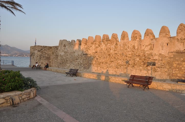
Kalés Fort
10 Str. SamouilThe fort Kales in Ierapetra was built by the Venetians in the 13th century AD, to protect the town of Ierapetra from its enemies. In 1508 it was destroyed by an earthquake and the Ottoman raids. The damage was not repaired, perhaps because it was very serious and there was no funding.
When the town of Ierapetra was occupied by the Turks in 1647, the fortress was repaired and used for the defense of the town. The name Kales comes from that period, since it comes from the Turkish word "kule", which means tower.
All these years Kales dominates the entrance to the old harbor of Ierapetra, witnessing the history of the city. Today you can visit the castle and watch the cultural events organized by the local municipality.
The mosque of Ierapetra was built in the old city (Kato Mera) at the end of the 19th century, when the Turks conquered Ierapetra and modified the church of Saint John (Agios Ioannis) for their religious purposes. It is held to date in a pretty good condition.
It is spacious and has a Muslim inscription from the Koran on the marble lintel of the entrance. Its minaret was repaired around 1953 and dominates the district. Opposite the mosque there is an Muslim fountain, which has also been restored.
10 personas locales recomiendan
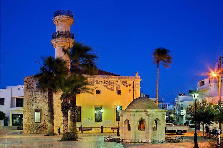
Platia Tzami
The mosque of Ierapetra was built in the old city (Kato Mera) at the end of the 19th century, when the Turks conquered Ierapetra and modified the church of Saint John (Agios Ioannis) for their religious purposes. It is held to date in a pretty good condition.
It is spacious and has a Muslim inscription from the Koran on the marble lintel of the entrance. Its minaret was repaired around 1953 and dominates the district. Opposite the mosque there is an Muslim fountain, which has also been restored.
In the summer of 1798 the French Emperor Napoleon Bonaparte conducted his campaign against the Mamluks in Egypt to protect the French trade in the region and to block the access of the Brits in India. During his trip to the east it is said to have stayed for a night in a house in Ierapetra.
Nobody noticed that it was him, until the family that hosted him, after his departure, saw a handwritten note that read in French "If you want to know who your stranger was, know that I am Napoleon Bonaparte'.
7 personas locales recomiendan
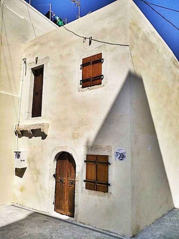
Spiti tou Napoleonta
9 NapoleonIn the summer of 1798 the French Emperor Napoleon Bonaparte conducted his campaign against the Mamluks in Egypt to protect the French trade in the region and to block the access of the Brits in India. During his trip to the east it is said to have stayed for a night in a house in Ierapetra.
Nobody noticed that it was him, until the family that hosted him, after his departure, saw a handwritten note that read in French "If you want to know who your stranger was, know that I am Napoleon Bonaparte'.
Toplou Monastery is located in the northeastern tip of Crete, at the base of Sidero Cape, 10km east of Sitia and 6km north of Palekastro. The monastery is one of the most historic monasteries of Crete and is known for its vast real property. In religious circles it is known as the Monastery of Panagia Akrotiriani, while the locals just call it the Great Monastery.
It is worth visiting Toplou, since you can combine the visit with the beautiful beaches of the area, the site of ancient Itanos and the famous palm grove of Vai. The area is the one of the most arid and inhospitable places on Crete, while the constant strong winds have attracted one of the first wind farms on the island.
The monastery celebrates on September 26, when a big fest takes place with pilgrims arriving from all over Greece. Toplou is open for the public daily, from 9:00 to 13:00 and from 14:00 to 18:00. Lastly, the monks produce and sell excellent products as organic wine, olive oil and raki.
61 personas locales recomiendan
Toplou Monastery
Toplou Monastery is located in the northeastern tip of Crete, at the base of Sidero Cape, 10km east of Sitia and 6km north of Palekastro. The monastery is one of the most historic monasteries of Crete and is known for its vast real property. In religious circles it is known as the Monastery of Panagia Akrotiriani, while the locals just call it the Great Monastery.
It is worth visiting Toplou, since you can combine the visit with the beautiful beaches of the area, the site of ancient Itanos and the famous palm grove of Vai. The area is the one of the most arid and inhospitable places on Crete, while the constant strong winds have attracted one of the first wind farms on the island.
The monastery celebrates on September 26, when a big fest takes place with pilgrims arriving from all over Greece. Toplou is open for the public daily, from 9:00 to 13:00 and from 14:00 to 18:00. Lastly, the monks produce and sell excellent products as organic wine, olive oil and raki.
Nature
Chrissi island or Gaidouronisi is located 8 miles south of Ierapetra city, in the open South Cretan Sea. It is a flat islet very famous for its tropical blue water that cover all possible palette hues of blue and green, the protected forest with large juniper trees and the thousands of broken shells that make the sand pinkish. The residents of Ierapetra love this island and call it simply "the Island".
Chrissi takes its name (golden in Greek) after the white sand that covers the entire island and comes mainly from shell debris. The tropical beaches are crowded by many visitors who come by the excursion boats that leave Ierapetra in the morning and return in the afternoon. Chrissi has been declared as an area of natural beauty and it is strictly prohibited to camp and spend your night here. You must keep away from the fragile juniper trees and avoid not collecting sand or shells.
https://www.cretanbeaches.com/en/islands-and-islets-around-crete/chrissi-island-gaidouronisi
107 personas locales recomiendan
Chrysi
Chrissi island or Gaidouronisi is located 8 miles south of Ierapetra city, in the open South Cretan Sea. It is a flat islet very famous for its tropical blue water that cover all possible palette hues of blue and green, the protected forest with large juniper trees and the thousands of broken shells that make the sand pinkish. The residents of Ierapetra love this island and call it simply "the Island".
Chrissi takes its name (golden in Greek) after the white sand that covers the entire island and comes mainly from shell debris. The tropical beaches are crowded by many visitors who come by the excursion boats that leave Ierapetra in the morning and return in the afternoon. Chrissi has been declared as an area of natural beauty and it is strictly prohibited to camp and spend your night here. You must keep away from the fragile juniper trees and avoid not collecting sand or shells.
https://www.cretanbeaches.com/en/islands-and-islets-around-crete/chrissi-island-gaidouronisi
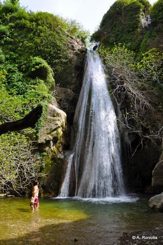
The gorge of Richtis is located in Lasithi Prefecture, on the north side of Crete, between the cities Agios Nikolaos and Sitia. The trail starts just outside the village Exo Mouliana and ends on the Richtis beach, east of the village Kalavros. The total length of the route is approximately 3 kilometers and the elevation difference between the starting point and the beach is about 350 meters. The gorge, even in summer, has enough water, which is used for local crops. The gorge collects the water from the peak Drymias (918m) of Orno range through the streams of Lachanas and Mesa Mouliana which merge near the starting point.
Hiking to the beach takes approximately three to four hours, depending on the hiking pace. The highlight of the gorge is, however, the beautiful waterfall Richtis with a height exceeding 20 meters and the smal pond formed below it (richtis means waterfall in the Cretan dialect). The waterfall has water even in summer and is a great place to have a refreshing dive. The path ends in the beautiful pebbly beach of Richtis. The beach has a small park with tamarisk trees, with stone seats and tables around and water fountain with potable water.
63 personas locales recomiendan
Richtis Gorge
The gorge of Richtis is located in Lasithi Prefecture, on the north side of Crete, between the cities Agios Nikolaos and Sitia. The trail starts just outside the village Exo Mouliana and ends on the Richtis beach, east of the village Kalavros. The total length of the route is approximately 3 kilometers and the elevation difference between the starting point and the beach is about 350 meters. The gorge, even in summer, has enough water, which is used for local crops. The gorge collects the water from the peak Drymias (918m) of Orno range through the streams of Lachanas and Mesa Mouliana which merge near the starting point.
Hiking to the beach takes approximately three to four hours, depending on the hiking pace. The highlight of the gorge is, however, the beautiful waterfall Richtis with a height exceeding 20 meters and the smal pond formed below it (richtis means waterfall in the Cretan dialect). The waterfall has water even in summer and is a great place to have a refreshing dive. The path ends in the beautiful pebbly beach of Richtis. The beach has a small park with tamarisk trees, with stone seats and tables around and water fountain with potable water.
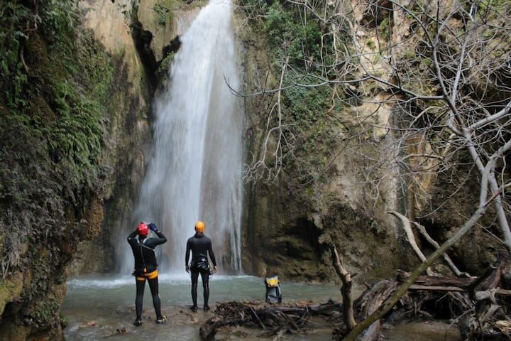
The Gorge of Mylonas or Saint John is located 18km east of Ierapetra and 8km from Pancratium.
It starts near the village of St. John, at an altitude of 500m, and ends at the beach of Kakia Skala. Descending the gorge from Saint John is impossible, as it is stopped by a high waterfall, and canyoning equipment is necessary.
However, the high fall of the canyon of Mylonas can be accessed through two ascending trails that start near the beach of Kakia Skala. The first trail (easy – 20’) comes on the pinewooded side of the gorge and a big part of it is the old concrete ditch, previously used for transferring water to Koutsounari. The other trail comes along the riverbed and especially in winter us very tiring (takes about 1:30 hour)
15 personas locales recomiendan
ENTRANCE PATHWAY FOR Waterfall of Milona
The Gorge of Mylonas or Saint John is located 18km east of Ierapetra and 8km from Pancratium.
It starts near the village of St. John, at an altitude of 500m, and ends at the beach of Kakia Skala. Descending the gorge from Saint John is impossible, as it is stopped by a high waterfall, and canyoning equipment is necessary.
However, the high fall of the canyon of Mylonas can be accessed through two ascending trails that start near the beach of Kakia Skala. The first trail (easy – 20’) comes on the pinewooded side of the gorge and a big part of it is the old concrete ditch, previously used for transferring water to Koutsounari. The other trail comes along the riverbed and especially in winter us very tiring (takes about 1:30 hour)
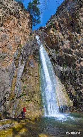
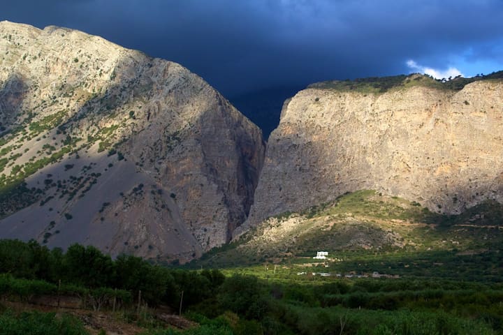
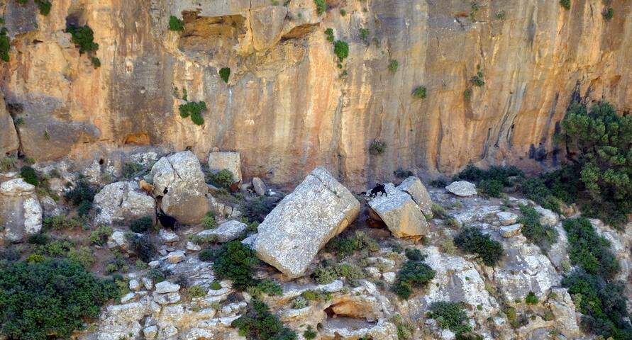
The imposing Gorge of Ha is considered the most beautiful technical gorge in Crete. It is formed on the western side of Mount Thrypti and transports the waters from the plateau of Thripti to the isthmus of Ierapetra, which are then moved on the beach of Pachia Ammos. The entrance of the gorge is located below the Byzantine church of Saint Anne (Agia Anna) at an altitude of about 800m, next to the European footpath E4 that connects the Minoan settlement of Vasiliki with Thripti. Its exit, reminiscent of a knife that has cut the mountain in two, is located at an altitude of 100m, next to the village Monastiraki.
22 personas locales recomiendan
Ha Gorge
The imposing Gorge of Ha is considered the most beautiful technical gorge in Crete. It is formed on the western side of Mount Thrypti and transports the waters from the plateau of Thripti to the isthmus of Ierapetra, which are then moved on the beach of Pachia Ammos. The entrance of the gorge is located below the Byzantine church of Saint Anne (Agia Anna) at an altitude of about 800m, next to the European footpath E4 that connects the Minoan settlement of Vasiliki with Thripti. Its exit, reminiscent of a knife that has cut the mountain in two, is located at an altitude of 100m, next to the village Monastiraki.
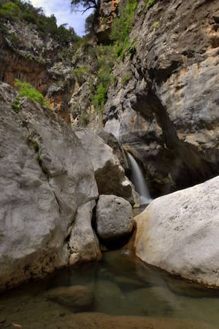
According to the greek mythology, the giant Sarantapihos, who was son of Zeus, once stopped to drink water from the river Kryos or Myrtos, near Ierapetra. His long beard slashed the mountain in two parts and created the canyon of Sarakina. Sarakina is located very close to the traditional village Mythi and near the seasise settlement of Myrtos, where the river Kryos exits to the sea.
It is considered by many visitors as the nicest hiking gorge in Crete. Its length reaches only 1.5km, but during this short course the visitor will meet an amazing wonder of the Cretan nature, a natural sculpture formed by water in millions of years. Sarakina has imposing walls reaching 150m height and very narrow passages, usually met in technical gorges (needing canyoneering equipment). Its width ranges from 3 to 10 meters, with only a few points exceeding that.
This is a canyon with most of its length being accessible by anyone, with water, ponds and only some climbing points requiring attention. What is really impressive is the large quantity of water almost all year round, that forms very beautiful waterfalls and ponds, ideal for swimming, even in summer. In winter, it is impossible to cross the gorge without getting wet. During the course one has to climb, come through huge boulders and rocky bridges. In tough positions, there are stairs carved in stone and some tree trunks for easiest climbing.
21 personas locales recomiendan
Sarakinas Gorge
According to the greek mythology, the giant Sarantapihos, who was son of Zeus, once stopped to drink water from the river Kryos or Myrtos, near Ierapetra. His long beard slashed the mountain in two parts and created the canyon of Sarakina. Sarakina is located very close to the traditional village Mythi and near the seasise settlement of Myrtos, where the river Kryos exits to the sea.
It is considered by many visitors as the nicest hiking gorge in Crete. Its length reaches only 1.5km, but during this short course the visitor will meet an amazing wonder of the Cretan nature, a natural sculpture formed by water in millions of years. Sarakina has imposing walls reaching 150m height and very narrow passages, usually met in technical gorges (needing canyoneering equipment). Its width ranges from 3 to 10 meters, with only a few points exceeding that.
This is a canyon with most of its length being accessible by anyone, with water, ponds and only some climbing points requiring attention. What is really impressive is the large quantity of water almost all year round, that forms very beautiful waterfalls and ponds, ideal for swimming, even in summer. In winter, it is impossible to cross the gorge without getting wet. During the course one has to climb, come through huge boulders and rocky bridges. In tough positions, there are stairs carved in stone and some tree trunks for easiest climbing.
Δασάκι Κουτσουρά
The beautiful Gorge of Kato Zakros (or the gorge of the Dead) starts in a short distance from Ano Zakros, nearly 100km southeast of Agios Nikolaos church and ends at Kato Zakros beach. The beauty of the landscape, the historical importance of the gorge and its accessibility, attract many visitors every year. The trail in the gorge is part of the E4 European trail.
It is an exceptionally beautiful gorge, with high walls with big caves on them. In those caves, tombs of the Minoan era, have been found, which contained findings of great archaeological value. Because of these tombs, the gorge is also called "Gorge of the Dead" and the caves "Caves of the Dead".
13 personas locales recomiendan
Zakros Gorge
The beautiful Gorge of Kato Zakros (or the gorge of the Dead) starts in a short distance from Ano Zakros, nearly 100km southeast of Agios Nikolaos church and ends at Kato Zakros beach. The beauty of the landscape, the historical importance of the gorge and its accessibility, attract many visitors every year. The trail in the gorge is part of the E4 European trail.
It is an exceptionally beautiful gorge, with high walls with big caves on them. In those caves, tombs of the Minoan era, have been found, which contained findings of great archaeological value. Because of these tombs, the gorge is also called "Gorge of the Dead" and the caves "Caves of the Dead".
Nearby the lush green and full of water springs Orino village we meet one of the most steep rivers of Crete. Its springs are located high on the plateau Abelia on the slopes of Thripti and Papouri mounts. They shortly form a river which crosses the village square and enters the rugged canyon of Orino. Descending the canyon along its riverbed requires canyoneering equipment. The river shapes incredible waterfalls with ponds and especially its last part is amazingly beautiful. The last three waterfalls at Peristerionas position are some of the most beautiful in Crete. Impressive also is the amount of water, very rare at dry East Crete. Even during the summer months there is water flow in the gorge.
The river continues to flow down and enters the canyon of Red Butterflies finishing at Koutsouras beach. Despite the fact that it has suffered major damage by a big fire in 1993, the vegetation in the Gorge with Red Butterflies is still lush and the gorge still constitutes a green lung of the warm eastern Crete. The gorge starts near the exit of Orino Gorge and ends at Koutsouras after 3-4 hour of walking (starting from Orino village and bypassing the wild part of Orino gorge). Along the route, there are signs indicating the path. At the beginning of the route, there are some small springs and waterfalls, which do not have water during summer months. However, in winter, the hiking in the gorge gets quite difficult. The gorge is named after the red butterflies that fly through the bushes and flowers, forming a truly rare sight! Unfortunately, in the years following the fire, their population has significantly decreased.
Orino Gorge
Nearby the lush green and full of water springs Orino village we meet one of the most steep rivers of Crete. Its springs are located high on the plateau Abelia on the slopes of Thripti and Papouri mounts. They shortly form a river which crosses the village square and enters the rugged canyon of Orino. Descending the canyon along its riverbed requires canyoneering equipment. The river shapes incredible waterfalls with ponds and especially its last part is amazingly beautiful. The last three waterfalls at Peristerionas position are some of the most beautiful in Crete. Impressive also is the amount of water, very rare at dry East Crete. Even during the summer months there is water flow in the gorge.
The river continues to flow down and enters the canyon of Red Butterflies finishing at Koutsouras beach. Despite the fact that it has suffered major damage by a big fire in 1993, the vegetation in the Gorge with Red Butterflies is still lush and the gorge still constitutes a green lung of the warm eastern Crete. The gorge starts near the exit of Orino Gorge and ends at Koutsouras after 3-4 hour of walking (starting from Orino village and bypassing the wild part of Orino gorge). Along the route, there are signs indicating the path. At the beginning of the route, there are some small springs and waterfalls, which do not have water during summer months. However, in winter, the hiking in the gorge gets quite difficult. The gorge is named after the red butterflies that fly through the bushes and flowers, forming a truly rare sight! Unfortunately, in the years following the fire, their population has significantly decreased.
The Gorge of Pefki (pefki means pines), also called Anegyrous Gorge, is one of the most beautiful small gorges of East Crete, with amazing rock formations shaped by the natural forces and with lush vegetation. The length of the gorge is approximatelly 4.5 km and the elevation difference of the entering point and the exit reaches 300 meters.The gorge starts south of the village Pefki and ends in Aspros Potamos settlement, 2km north of Makrigialos. Its stream collects the waters from the area south of the peak Romanati (937m) and transports them to the beach of Analipsi. The canyon has a well shaped path, which follows the riverbed almost in its entire length. Moreover, at some point you will see some benches where you can rest. The route in the gorge can hold 2 hours and is part of the E4 European long distance path.
THE ROUTE
The gorge starts a bit south from Pefki, where the typical black and yellow E4 signs head to the entrance, next to the old water mill of Ilias (1925). From there take the easy path along the sides of the canyon and later follow the descending path that leads to the river bed, in the heart of the gorge. The canyon is lush and full of pine trees around, while next to the riverbed the vegetation constitutes mostly from platans and herbs. There amazing white rock formations on the sides, unique in Crete, exceed 100 meters in height.
As you arrive at the southern exit of the gorge, you will find a spring of clean potable water, where you can cool off. The exit of the canyon is not near the sea but in Pisokaminos area, close to the village of Aspros Potamos. A little later, you will meet the impressive large rock called the Volakas Sarakinou (rock of the Saracen). According to the tradition, a Saracen pirate was hiding himself in there, after being abandoned in Crete. On the rock you’ll see many small pebbles. A legend wants them to be a result of an old game; the children that were passing from this area, threw stones on Volakas to see if they will find food at home. If the stone remained on the rock, then they would find food, otherwise not. After the village Aspros Potamos, you will meet the main road linking Makrigialos with Pefki. If nobody waits for you by car, you have to walk the remaining 2km to Makrigialos.
15 personas locales recomiendan
Pefki Gorge
The Gorge of Pefki (pefki means pines), also called Anegyrous Gorge, is one of the most beautiful small gorges of East Crete, with amazing rock formations shaped by the natural forces and with lush vegetation. The length of the gorge is approximatelly 4.5 km and the elevation difference of the entering point and the exit reaches 300 meters.The gorge starts south of the village Pefki and ends in Aspros Potamos settlement, 2km north of Makrigialos. Its stream collects the waters from the area south of the peak Romanati (937m) and transports them to the beach of Analipsi. The canyon has a well shaped path, which follows the riverbed almost in its entire length. Moreover, at some point you will see some benches where you can rest. The route in the gorge can hold 2 hours and is part of the E4 European long distance path.
THE ROUTE
The gorge starts a bit south from Pefki, where the typical black and yellow E4 signs head to the entrance, next to the old water mill of Ilias (1925). From there take the easy path along the sides of the canyon and later follow the descending path that leads to the river bed, in the heart of the gorge. The canyon is lush and full of pine trees around, while next to the riverbed the vegetation constitutes mostly from platans and herbs. There amazing white rock formations on the sides, unique in Crete, exceed 100 meters in height.
As you arrive at the southern exit of the gorge, you will find a spring of clean potable water, where you can cool off. The exit of the canyon is not near the sea but in Pisokaminos area, close to the village of Aspros Potamos. A little later, you will meet the impressive large rock called the Volakas Sarakinou (rock of the Saracen). According to the tradition, a Saracen pirate was hiding himself in there, after being abandoned in Crete. On the rock you’ll see many small pebbles. A legend wants them to be a result of an old game; the children that were passing from this area, threw stones on Volakas to see if they will find food at home. If the stone remained on the rock, then they would find food, otherwise not. After the village Aspros Potamos, you will meet the main road linking Makrigialos with Pefki. If nobody waits for you by car, you have to walk the remaining 2km to Makrigialos.
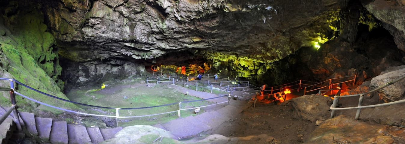
The impressive cave of Zeus, the Diktaean Cave, is located above the village Psychro in Lassithi Plateau at an altitude of 1025m. In Psychro there is plenty of parking space, with plenty of restaurants nearby. Two paths leading to the cave start from the parking area. The easiest path is the left one, because in the right path (the oldest) the stones are worn by thousands of tourists and are slippery. The route to the cave is magnificent as the view to the Lassithi Plateau is breathtaking. If you do not want to walk, there are donkeys for transfering the visitors to the cave. Near the entrance of the cave there is a kiosk where you can buy tickets for a small price. The cave, which has an area of 2200 sq.m, is well lit and the paths in it come along a well-designed path of 250m length.
Near the entrance, on the right there is a hall, while the great hall starts at a lower level. Southeast of the chamber there is a large stalagmite complex. Also, there are some buildings. A smaller hall is located on the northwest side. While moving inside the cave, the visitor enters the great hall with the largest part of it being covered by solid rock and large stalagmites. In the second part of the cave, there is a large and very spectacular stalactite, called as the “mantle of Zeus”. Unfortunately, this stalagmite has been damaged by visitors. The entire great hall has impressive decor with large columns, stalactites and stalagmites.
Cold Cave
The impressive cave of Zeus, the Diktaean Cave, is located above the village Psychro in Lassithi Plateau at an altitude of 1025m. In Psychro there is plenty of parking space, with plenty of restaurants nearby. Two paths leading to the cave start from the parking area. The easiest path is the left one, because in the right path (the oldest) the stones are worn by thousands of tourists and are slippery. The route to the cave is magnificent as the view to the Lassithi Plateau is breathtaking. If you do not want to walk, there are donkeys for transfering the visitors to the cave. Near the entrance of the cave there is a kiosk where you can buy tickets for a small price. The cave, which has an area of 2200 sq.m, is well lit and the paths in it come along a well-designed path of 250m length.
Near the entrance, on the right there is a hall, while the great hall starts at a lower level. Southeast of the chamber there is a large stalagmite complex. Also, there are some buildings. A smaller hall is located on the northwest side. While moving inside the cave, the visitor enters the great hall with the largest part of it being covered by solid rock and large stalagmites. In the second part of the cave, there is a large and very spectacular stalactite, called as the “mantle of Zeus”. Unfortunately, this stalagmite has been damaged by visitors. The entire great hall has impressive decor with large columns, stalactites and stalagmites.
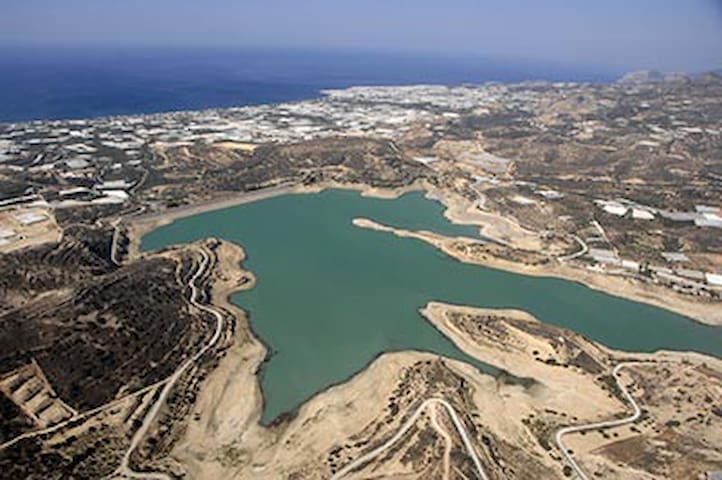
The artificial lake of Bramiana was built in 1986 near village Bramiana to meet the 30.000 of the greenhouses around Ierapetra. It is located 5km northwest of the town, in the road connecting Ierapetra with Kalamafka village. The lake covers an area of 1050 acres and has a capacity of 15 million m3, making it the second largest wetland of southern Greece, after Potami Dam at Amari. The best period to visit is in early spring, when water level is at its peak, while during some summers, one can see the chuch of Prophet Elijah appearing from the bottom of the lake.
6 personas locales recomiendan
Bramianos Reservoir
The artificial lake of Bramiana was built in 1986 near village Bramiana to meet the 30.000 of the greenhouses around Ierapetra. It is located 5km northwest of the town, in the road connecting Ierapetra with Kalamafka village. The lake covers an area of 1050 acres and has a capacity of 15 million m3, making it the second largest wetland of southern Greece, after Potami Dam at Amari. The best period to visit is in early spring, when water level is at its peak, while during some summers, one can see the chuch of Prophet Elijah appearing from the bottom of the lake.
The island has beautiful sandy beaches, it is mainly covered with fine sand and the scenery is not very different from an African desert. Visitors can admire the beauty of white rocks next to the blue of the sea and enjoy the tranquility of nature in turquoise waters. The landscapes alternate from the steep rocky shoreline, to the caves of yellow marl and the endless dunes.
https://www.cretanbeaches.com/en/islands-and-islets-around-crete/koufonissi-islet-lefki
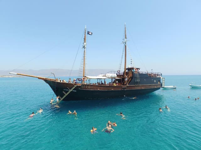
There is a Full-Day Trip with a Pirate Boat from Makri-gialos.
Choose a day without wind.
17 personas locales recomiendan
Koufonisi
The island has beautiful sandy beaches, it is mainly covered with fine sand and the scenery is not very different from an African desert. Visitors can admire the beauty of white rocks next to the blue of the sea and enjoy the tranquility of nature in turquoise waters. The landscapes alternate from the steep rocky shoreline, to the caves of yellow marl and the endless dunes.
https://www.cretanbeaches.com/en/islands-and-islets-around-crete/koufonissi-islet-lefki
There is a Full-Day Trip with a Pirate Boat from Makri-gialos.
Choose a day without wind.